
Army veteran sets off fireworks, starts fire outside NYC federal building, FBI says

▶ Watch Video: Veteran lit fire on steps of federal building in Lower Manhattan, investigators say

A man was arrested after the FBI and New York City Police Department said he ignited fireworks and started a fire outside a federal building in Lower Manhattan on Monday morning.

The incident happened at 8:20 a.m. outside 26 Federal Plaza, a building that houses dozens of agencies including the FBI, Immigration and Customs Enforcement, and U.S. Citizenship and Immigration Services. 

Officials identified the suspect as Andrew Arrabaca, 43, a U.S. Army veteran from Poughkeepsie with an address in Harlem.

According to a U.S. Army spokesperson, Arrabaca served in the regular Army from July 2001 to July 2004 and in the Army National Guard-New York from July 2004 to July 2005. He had no deployments and left the Army in the rank of specialist.

“He came armed with bad intentions”  

FBI New York Assistant Director James Barnacle said Arrabaca was armed with two axes, a machete, three knives, fireworks and other destructive devices.

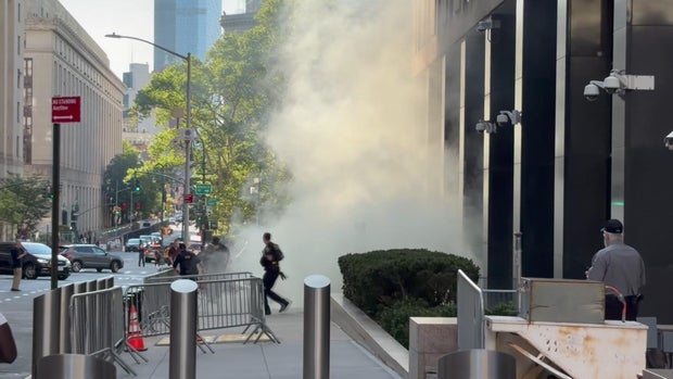
NYPD Commissioner Jessica Tisch said the suspect ignited a bundle of fireworks before dumping flammable liquid outside the building and setting it on fire. 
federal-plaza-fireworks-spec-hi-res-still.jpg
Heavy smoke was seen outside 26 Federal Plaza after an explosion caused by fireworks, sources said. 

CBS News New York

Federal agents ran up to the suspect and tackled him, and the fire department quickly put out the blaze.

“He came armed with bad intentions,” Barnacle said. “Looking to injure people and harm people.”

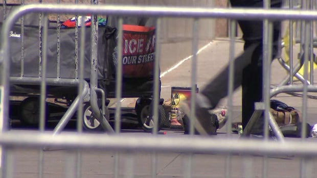
He described Arrabaca as an anti-ICE activist who had a small cart with him with the slogan “ICE off our streets” written on it.

“He is an anti-American, anti-government extremist,” Barnacle said.

Police sources said Arrabaca has had a previous encounter with federal agents for acting as an emotionally disturbed person but was not arrested. 

The FBI New York Joint Terrorism Task Force is investigating the incident.

Airsoft guns, commercial-grade fireworks found

The suspect was carrying two airsoft guns, according to Tisch. 

CBS News law enforcement analyst Richard Esposito described the materials as “things you might use in paintball-type events.”

Tisch said he fired several pellets into the air before he doused parts of the building in flammable liquid.

The DHS spokesperson said the man’s bag also contained a manifesto. 
gainer-12p-pkg-federal-wcbsihdg-hi-res-still.jpg
An airsoft rifle, carbon dioxide cartridges, halogen lighting and a helmet were among the items found at 26 Federal Plaza after an explosion. 

CBS News New York

Law enforcement has seized Arrabaca’s car and is working to obtain a search warrant for it.

3 minor injuries at 26 Federal Plaza, FBI says

Barnacle said three people were hurt, two of whom were government employees.

One person was grazed by the fireworks, a DHS spokesperson said. A security officer also had minor injuries after tackling the suspect. 

Video from the scene showed heavy smoke in front of the building and law enforcement arresting a man. 

New York City Mayor Zohran Mamdani called the incident “deeply disturbing.”

“My team is in touch with the NYPD, and we will support the federal investigation. Our administration will continue to ensure that every New Yorker is safe in their city — and hold accountable any who threaten that,” he wrote, in part, on social media

Tropical Storm Bertha slowly strengthens, threatening flooding as it trudges toward Gulf Coast

(CNN) — Tropical Storm Bertha is slowly organizing in the northeastern Gulf, where it is expected to bring several days of heavy rain, gusty winds and coastal flooding to parts of the Gulf Coast from Florida to Louisiana.🌀 ⛈️ Get your forecast the storm in the CNN Weather appBertha may have earned a name, but it still isn’t a well-organized tropical cyclone. Most of its strongest thunderstorms remain confined to the southern half of the circulation, while dry air continues to disrupt development despite fuel from near-record warm Gulf water.It’s the second named storm of the Atlantic hurricane season, which has gotten off to a slow start compared to recent years as El Niño tightens its grip on parts of the basin.The National Oceanic and Atmospheric Administration predicts a lower-than-average number of named systems in the Atlantic this season because of it.Storm track, intensityBertha will most likely track along the Gulf Coast and make landfall by late Wednesday night as a weak tropical storm near southeast Louisiana and southern Mississippi.Bertha is expected to face increasingly hostile conditions, like storm-killing wind shear, over the next several days that should limit how much stronger it becomes.The shear has already displaced most of Bertha’s thunderstorms to the south of its center, preventing the storm from becoming better organized.Tropical systems interacting with dry air and land tend to weaken because they’re deprived of the warm, moist ocean conditions that fuel their thunderstorms.These unfavorable factors could even cause the system to dissipate over Louisiana, but the latest forecast calls for it to reach the Upper Texas Coast as a tropical depression by late week.Impacts expected on Gulf Coast starting MondayRegardless of the system’s fate, heavy rainfall, gusty winds and some coastal flooding will impact the northern Gulf Coast Monday night through at least midweek.A tropical storm warning has been issued for coastal Alabama, Mississippi and eastern Louisiana. In these areas, tropical storm conditions are expected within the next 36 hours.A tropical storm watch has been issued for the coast of the Florida Panhandle from the Ochlockonee River west to the Jefferson-Plaquemines Parish border in Louisiana. In these locations, tropical storm conditions are possible within the next 24 to 48 hours. Additional watches could be issued farther west along the Louisiana coast and into Texas in the next day or two.Here’s what to expect:• Rainfall: Widespread totals of 2 to 4 inches, with up to 6 inches in the strongest thunderstorms, are possible from the western Florida Panhandle to southern portions of Alabama, Mississippi, Louisiana and possibly the Texas coast. This could trigger flash flooding, especially in urban areas like New Orleans.• Wind: Tropical storm conditions — sustained winds of 39+ mph — are possible in the tropical storm warning area of the Alabama, Mississippi and eastern Louisiana coasts Monday night into Tuesday. Locations in the western Florida Panhandle and coastal Louisiana in a tropical storm watch could see those conditions late Tuesday night into Wednesday. Higher gusts in thunderstorms could cause isolated power outages.• Storm surge: Water levels could rise 2 to 4 feet above normal from the mouth of the Mississippi River in southeast Louisiana to the Alabama-Florida border. A storm surge watch is in effect for this area, which means life-threatening inundation of ocean water is possible in the next 48 hours.The-CNN-Wire™ & © 2026 Cable News Network, Inc., a Warner Bros. Discovery Company. All rights reserved.
Read Next Story