▶ Watch Video: Millions of Americans under heat alerts
A heat wave continues to bake huge sections of the United States, lingering in parts of the desert Southwest and across the northern tier of the country. Across parts of the South, especially Texas, severe storms were forecast to bring heavy rain and possible flooding.
Extreme heat warnings and heat advisories were set to remain in place through Thursday in northern states including Montana, the Dakotas, Minnesota, Wisconsin and Michigan, and stretching across the Northeast, covering an area that’s home to at least 130 million people.
Maps show heat alerts
The heat index — which accounts for temperatures as well as humidity — was forecast to peak across the northern Plains on Tuesday, hovering around 110 degrees Fahrenheit.
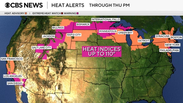
Nikki Nolan/CBS News
Temperatures alone were expected to be 20 to 30 degrees above average for this time of year, said CBS News meteorologist Nikki Nolan.
Some areas will hit triple digits, while a handful of locations could see record or near-record temperatures. In Fargo, North Dakota, temperatures could reach 99 degrees on Tuesday, which would challenge a daily record set in 1936.
Temperatures in Rapid City, South Dakota, may climb to 105 degrees Tuesday, which would break a record set in 2012.
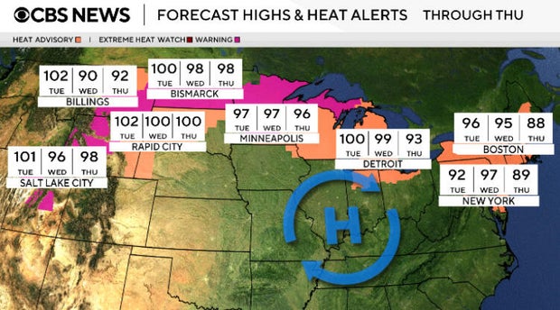
Nikki Nolan/CBS News
Farther east, Syracuse, New York, could hit 97 degrees, which would mark its hottest July 14 in more than 70 years.
The heat is expected to peak in the Northeast over the next couple of days, with states along the East Coast bracing for the worst conditions on Wednesday.
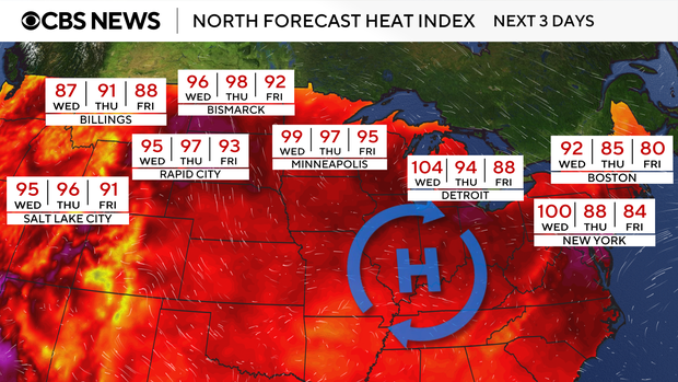
Nikki Nolan/CBS News
Severe heat is also continuing to bake the West, driving up risks of wildfires and heat-related health issues.
In California, extreme heat warnings and advisories were in place for a vast stretch from San Francisco to Los Angeles. Triple-digit temperatures were expected in and around Southern California, which wasn’t likely to experience relief overnight, as low temperatures could reach record heights, said Nolan.
Rain and flood risk
Another 20 million or so were under flood alerts in Texas, as a stationary weather system parked over the South delivers multiple rounds of heavy rain and thunderstorms.
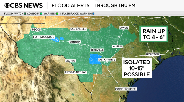
Nikki Nolan/CBS News
Texas Hill Country, which bore the brunt of the destruction caused by the deadly floods in July 2024, faces the most significant threats, said Nolan. Metropolitan areas including Houston and San Antonio could feel some of the impacts, too.
In Hill Country, the weather service has highlighted the risks of excessive rainfall potentially leading to flash flooding, as rainfall rates could reach 2 or 3 inches per hour or higher. The hardest-hit areas could receive between 10 and 15 inches of rain, while about 4 to 6 inches of rainfall was expected to be more widespread.