
The D.C. region is getting a nice holiday gift: The weather will be mild on Christmas Day.
More stories
Although some light drizzle made an appearance in the early morning as it moved through parts of Virginia, residents across the D.C. region can anticipate some above-average temperatures as the sun begins to shine through mostly cloudy skies.
Thursday temperatures will hit their max just near 60 degrees before plummeting back to the upper 20s by nightfall. Make sure to stay bundled up tonight.
According to 7News First Alert Meteorologist Matt Ritter, the area isn’t quite out the rainy neck of the woods just yet as there’s still a chance for another dose of passing rain in the afternoon.
“The atmosphere is just unsettled enough that there’s still a risk of a passing shower through the early afternoon, including the start of the Commanders-Cowboys game,” he said. “The sunshine we’re getting today will help warm the ground, and that’s a key element to the forecast for tomorrow.”
Looking to Friday, Ritter said there’s a chance the D.C. area could experience some wintry weather “with just a low impact for travelers.” (Phew!)
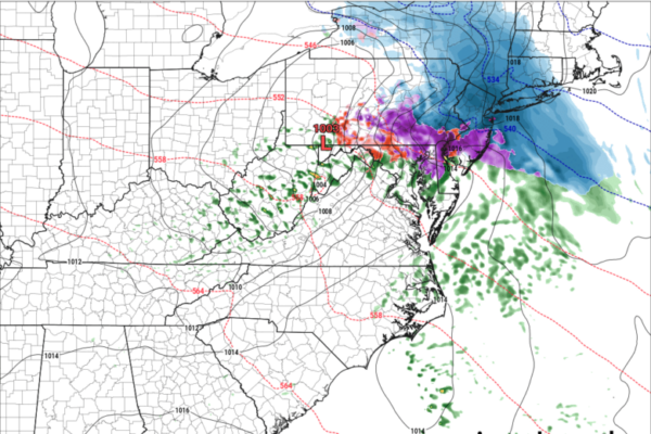
For the District, the majority of Friday’s more inclement weather will come in the form of rain, with residents closer to central Virginia experiencing less and less of the water works, Ritter said. The wintry mix comes into play for Maryland, specifically the Old Line State’s northern regions.
“Northern Maryland will get that mix of cold rain, sleet, and patchy freezing rain,” Ritter said. “We’re not expecting a widespread serious icing event there, at least not on treated surfaces.”
“The worst of the wintry weather will be in central Pennsylvania toward northern New Jersey,” he added.
At present, no winter storm watches or weather advisories have been issued for the D.C. region. Radars, according to Ritter, indicate “everything ending around midnight.”
Come Saturday, the weather makes a turn for more dry, seasonable conditions. Expect a mostly cloudy forecast with highs in the mid 40s Saturday, and a Sunday that offers more of the same but with a chance for rain.
- Listen to WTOP online and on the radio at 103.5 FM or 107.7 FM.
- Current traffic conditions
- Weather forecast
- Closings and Delays
- Sign up for WTOP email alerts
- Get custom alerts with the WTOP app for Apple and Android phones
FORECAST
CHRISTMAS: Mostly cloudy with a chance for a few spotty showers until early afternoon. Mild.
Highs: mid 50s to near 60.
TONIGHT: Clear early with increasing clouds. Colder than last night.
Lows: upper 20s to low 30s.
FRIDAY: Cloudy and cold. Light rain arriving by midday, wintry mix of sleet and freezing rain in northern Maryland.
Highs: mid 30s to near 40.
SATURDAY: Mostly cloudy.
Highs: mid 40s.
SUNDAY: Cloudy with showers arriving.
Highs: mid 40s to near 50.
CURRENT CONDITIONS
Get breaking news and daily headlines delivered to your email inbox by signing up here.
© 2025 WTOP. All Rights Reserved. This website is not intended for users located within the European Economic Area.


