
The D.C. area is in for an average to below-average winter of snowfall and just slightly milder temperatures than normal, according to the winter forecast from WTOP’s partners in the 7News First Alert Weather Center.
Related stories
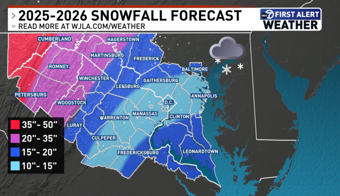
The seasonal average snowfall in D.C. is 13.7 inches, and First Alert Weather is forecasting between 10 and 15 inches for the District and the close-in suburbs.
A bit farther north and west, in places such as Frederick, Maryland, and Leesburg, Virginia, First Alert Weather is anticipating between 15-20 inches of snowfall. The forecast also projects 15-20 inches for Southern Maryland.
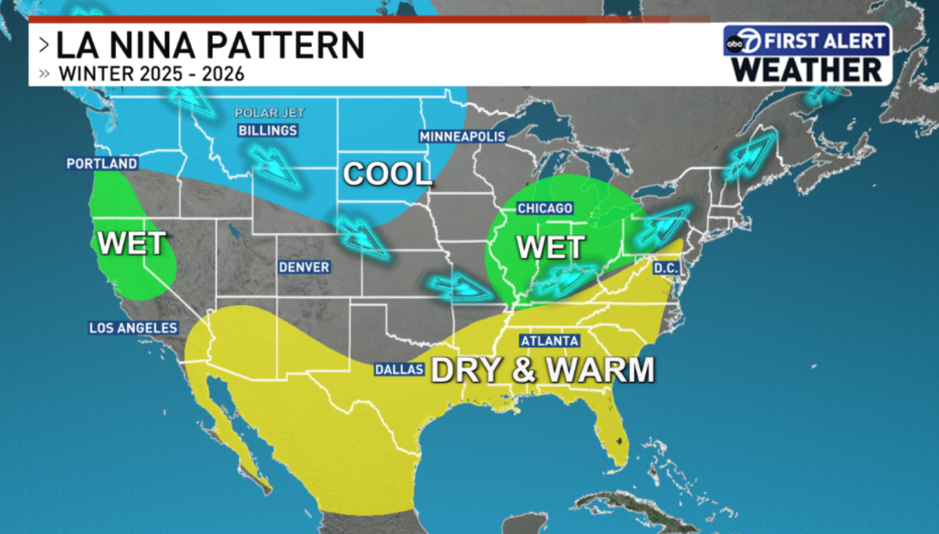
The slightly below-average projection is driven by La Niña, which can also make things hard to predict in the mid-Atlantic region. The La Niña pattern typically affects the jet stream in a way that leads to more precipitation in northern parts of the U.S. and warmer and drier conditions in the South.
But that’s not always the case, and D.C. is positioned right in the middle.
Just last winter, with a La Niña pattern in effect, D.C. got an above-average 14.9 inches of snow.
“It doesn’t take very much in terms of fluctuation of weather patterns, a jet stream that’s maybe a little more south of there, to give us that wet weather. And what we’re looking at then this year … is going with conditions that were similar to last year,” 7News First Alert Chief Meteorologist Veronica Johnson said.
[connatix_element_embed script_id=088c10e8d904466a8031fee5db51094e player_id=7bc491b4-922b-4e8d-b1b1-150648e80442 video_id=08d0832b-ac52-4c09-b3b7-1afdad031a42 align=right]
As was the case last winter, it only takes one big storm to drastically change D.C.’s snowfall totals.
So when might that happen? Johnson said don’t hold your breath for a white Christmas, though there could be a smattering of snow.
The First Alert Weather Center is forecasting 2-3 inches of snow for the month of December, which historically sees less snowfall in the mid-Atlantic.
The main event may come in January, as it did last year when a storm during the first full week of the new year dumped up to 10 inches in parts of the D.C. region.
“Coastal storms during this time could give us all of that in one big storm. So it’s really something that we’re going to have to watch, especially with the position of the jet stream,” Johnson said. “But if that jet (stream) comes in and hugs the coast, and you’ve got some coastal storms that are tracking right along it up the coast, that could be your 5-10 inches in one storm during the month of January. And I do think that it’s still going to be active during the month of February.”
Johnson said her team is projecting 3-7 inches of snowfall in February.
“It’s a pattern that fits kind of a slow start, but a pretty good finish,” she said.
As far as temperatures, the First Alert Weather Center said it may shape up to be a slightly milder winter than normal. But that doesn’t mean there won’t be cold snaps.
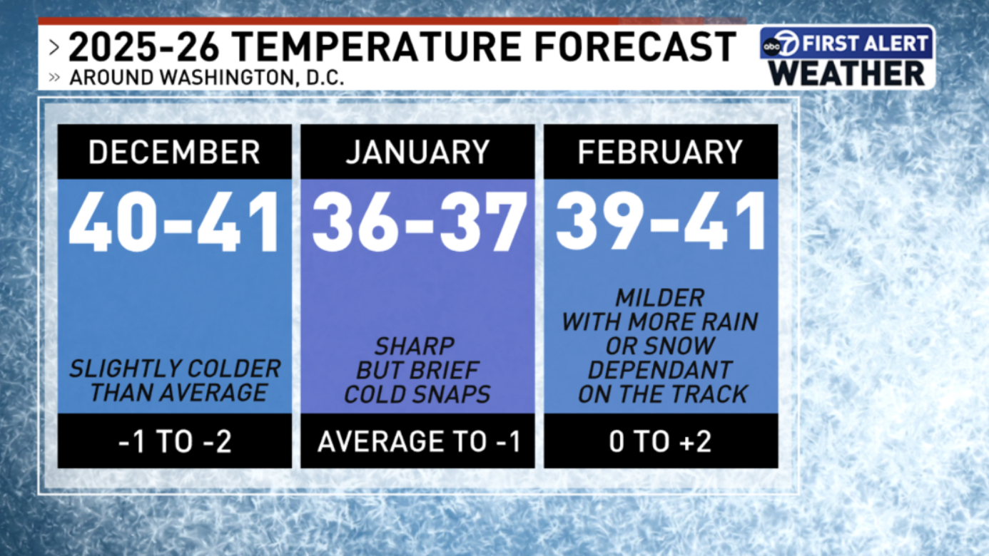
“All it takes is these cold stretches during the winter,” Johnson said. “Overall, the temperatures can average out slightly higher, but with a couple of cold stretches embedded during the month of January and February, we can get that snowfall.”
And if La Niña neutralizes toward the end of winter, that could mean more precipitation during the month of February.
“The other thing we’re going to have to watch this winter too is the potential to get some storms, unlike last year, that have a bit more freezing rain at the beginning or at the tail end,” Johnson said.
While there’s plenty of data to provide a road map, Johnson pointed out that forecasting is not an exact science and winter can be full of surprises.
“If there was some magical ball that we could look at to come up with a forecast, boy, I sure would be using that to win the lottery,” she said. “So it is not set in stone. I would say at this point, it’s a forecast, it’s somewhere around 65% to 70% confidence factor in it with a winter that has yet to start.”
Meteorological winter begins Dec. 1.
Get breaking news and daily headlines delivered to your email inbox by signing up here.
© 2025 WTOP. All Rights Reserved. This website is not intended for users located within the European Economic Area.


