
From ground stops to fire alerts and wind advisories, the D.C. region got its fair share of weather-related notifications Sunday.
For much of the day, until 6 p.m., the day’s gust winds and low humidity forced the National Weather Service to issue a Fire Weather Watch.
“It’s the prolonged nature of the dry conditions that will lead to the increased fire threat,” 7News First Alert Meteorologist Mark Peña said. Any outdoor cooking or smoking is discouraged.
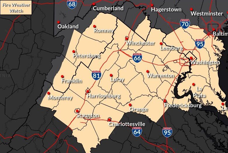
The region has had very dry conditions since August, with “the driest August on record,” Peña said. “We haven’t had enough rainfall to really recover from that.”
Windy conditions throughout the day contributed to local power outages.
In Maryland, thousands were without power in Prince George’s and Montgomery counties. As of 4 p.m., the hardest hit was Baltimore. In Virginia, Dominion Energy said that more than 1,200 households in Fairfax County were without power, too.
Strong winds also impacted flights at Dulles International airport, where arriving flights experienced hour-plus delays on average.
Ground stops also held up passengers throughout the day. If you’re planning to fly, check with your airline for the most up-to-date flight information.
A cold alert issued by D.C. Mayor Muriel Bowser remains in effect for the District from 8 p.m. Sunday through 9 a.m. Monday. The alert is triggered when daytime or overnight temperatures feel like 32 degrees or colder.
Residents in need of shelter or assistance can visit cold.dc.gov, call the city’s shelter hotline at 202-399-7093 or dial 311. D.C. officials also urge residents to check on neighbors, particularly seniors, children and people with disabilities.
Expect chilly daytime highs in the 50s Monday, coupled with gusty northwest winds adding an extra chill.
More clouds than sun and showers are expected Tuesday afternoon, with a 40% chance of rain. Showers may linger overnight.
Wednesday brings more clouds than sun, rain chances are low. Highs will be in the low to mid-50s, with wind chills in the 40s.
- Listen to WTOP online and on the radio at 103.5 FM or 107.7 FM.
- Current traffic conditions
- Weather forecast
- Closings and Delays
- Sign up for WTOP email alerts
- Get custom alerts with the WTOP app for Apple and Android phones
7News First Alert Forecast
SUNDAY EVENING: FIRE ALERT
Mostly clear, windy
Temperatures: 50s
Winds: Northwest 15-25 mph; Gusts: 40-50 mph
Mainly clear skies but remaining very windy with an elevated fire risk through the evening.
SUNDAY NIGHT:
Mostly clear
Lows: 32-38
Winds: West 10-20 mph
Clouds will clear but winds will remain out the west at 10 to 20 mph, putting wind chills in the upper 20s to low 30s.
MONDAY:
Mostly sunny, breezy
Highs: 48-53
Winds: Northwest 15-25 mph
Gusts: 30-35 mph
Chilly daytime highs in the 50s coupled with gusty northwest winds will add an extra chill to the air Monday. Lower temperatures are on the way Tuesday.
TUESDAY:
Increasing clouds, evening showers
Highs: 45-50
Wind Chill: 40s
Winds: South 5-10 mph
Expect more clouds than sun and showers developing in the afternoon. Chance of rain is only at 40% at this time, and rain showers may linger into the overnight.
WEDNESDAY:
Mostly cloudy
Highs: 50-55
Wind Chill: 40s
Winds: Northeast 5 mph
Expect more clouds than sun but chances for rain are very low at this time. Highs will remain slightly below-average in the low to middle 50s.
THURSDAY:
Cloudy
Highs: 54-59
Winds: Southeast 5 mph
Mainly cloudy and dry with mild, seasonable temperatures.
OUTAGES
Get breaking news and daily headlines delivered to your email inbox by signing up here.
© 2025 WTOP. All Rights Reserved. This website is not intended for users located within the European Economic Area.


