
(NEW YORK) — El Nino conditions continue to intensify and are likely to be very strong, resulting in a potentially historic event in the coming months that could significantly influence our weather, the hurricane season and global temperatures, according to the latest forecast from the National Oceanic and Atmospheric Administration (NOAA).
The agency is now highly confident there will be a very strong El Nino during the upcoming Northern Hemisphere fall and winter seasons.
NOAA’s latest forecast says that between October and December, there is a 69% chance of a historic event that would exceed the strength of all previous El Nino events on record, dating back to 1950. The current event ranks as the second strongest on record for this time of the year, behind 1997.
“Our team has become more confident in the possibility of a very strong El Nino by the end of this year,” Michelle L’Heureux, a physical scientist at NOAA’s Climate Prediction Center, told ABC News.
“There is a greater than 90% chance of a ‘very strong’ El Nino, which is the highest chance to date, and expresses our confidence in the growth and development of a potentially historic El Nino event,” L’Heureux added.
NOAA noted that with an event of this magnitude, while the chances of experiencing impacts consistent with El Nino are greater, they are not guaranteed.
El Nino refers to the warmer-than-average phase of the El Nino–Southern Oscillation (ENSO), a natural cycle where sea surface temperatures across the central and eastern equatorial Pacific Ocean rise and fall. The cooler-than-average phase is called La Nina, while near-average conditions are known as ENSO-neutral.
NOAA ranks the strength of El Nino events by measuring the sea surface temperature departure from average (anomaly) across this region, classifying events as weak, moderate, strong or very strong.
While adjectives such as “super” and “extreme” are popular ways of describing the strength of an El Nino event on social media, NOAA and the WMO classify the strength as weak to moderate, strong and very strong. The WMO noted in a recent statement that “the term [[super]] is not part of standardized operational classifications.”
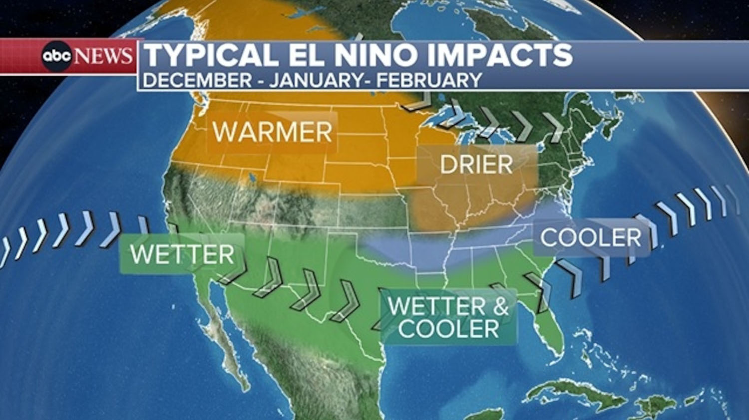
Typical El Nino impacts across the United States
Impacts from El Nino, similar to La Nina, tend to be most consistent and pronounced from late autumn through early spring following the event’s onset, NOAA said. There is usually a delay between the onset of the event and many of the associated effects.
Experts caution that the impacts on weather patterns are nuanced. Each season is different, and typical El Nino conditions don’t always materialize.
“The data is very clear that we can be more confident in certain impacts occurring during strong and very strong El Nino, but it is really important to emphasize that even if this ends up being a historic El Nino, there will be impacts in some locations that do not align with the expected El Nino impact,” L’Heureux added. “This is why our seasonal forecasts are expressed in terms of probabilities.”
Northeast: Typically, during El Nino, warmer-than-average temperatures are favored across the northern half of the United States during the winter months. However, its influence is less pronounced in the Northeast, compared to the Upper Midwest and Northwest.
El Nino typically increases the odds of above-average snowfall in the mid-Atlantic and coastal areas of the Northeast as storms often move up the coast. Farther inland, drier-than-average conditions and less snow are more likely.
South: Near- to below-average temperatures are favored along the southern tier of the U.S., especially from Texas to the Southeast.
For precipitation, wetter-than-average conditions are typically observed along the southern tier of the U.S., including parts of the Gulf Coast and Southeast. Below-average precipitation is frequently observed across parts of the south-central Mississippi Valley.
Midwest: Warmer-than-average temperatures are favored from the northern Plains into the Great Lakes. Drier-than-average conditions are frequently observed across parts of the Ohio Valley and Great Lakes regions.
El Nino typically increases the odds of above-average snowfall in the south-central Plains, with below-average snowfall favored in the northern Plains and Great Lakes regions.
West: During the winter months, warmer-than-average temperatures are likely across much of the Northwest. For precipitation, wetter-than-average conditions are typically observed across southern California and much of the Southwest, with below-average precipitation frequently observed across parts of the northern Rockies.
El Nino typically increases the odds of above-average snowfall in the southern Rockies, with below-average snowfall favored in the northern Rockies.
Meanwhile, above-average tropical activity in the eastern Pacific increases the likelihood of indirect impacts to the southwestern United States, such as sending more rain to the region and more frequent flash flood concerns.
Alaska: El Nino impacts in Alaska tend to be more pronounced than across much of the contiguous United States, with the strongest effects typically occurring during the winter and spring months. During winter, warmer- and drier-than-average conditions are more likely, with less snowfall and reduced snowpack.
Above average temperatures often persist into spring, while precipitation trends closer to average. However, warmer conditions typically mean more precipitation falls as rain rather than snow, prolonging snow deficits.
Hawaii: Rainfall is typically above average across Hawaii the year an El Nino event develops before conditions become drier during the winter months and remain dry well into the following year. The shift toward drier weather can increase the likelihood of drought and elevate the risk of wildfires.
Meanwhile, above-average tropical activity in the eastern Pacific increases the risk of impacts from tropical systems across the Hawaiian Islands.
How El Nino influences hurricane season activity
While El Nino is only one of several key factors that influence tropical activity, forecasts now indicate it will be a strong event through the peak of the hurricane season, making it the primary driver of activity in both the Atlantic and eastern Pacific in the coming months.
El Nino conditions often suppress tropical activity during the Atlantic hurricane season by producing unfavorable atmospheric winds. In the Eastern Pacific, the opposite occurs, with favorable conditions supporting above-average hurricane season activity.
Other factors, such as sea surface temperatures, also play an important role in tropical cyclone development and strength. Unseasonably warm ocean waters can partially offset the effects of unfavorable atmospheric winds, according to forecasters.
Global temperature records will likely be challenged
2024 ranked as the planet’s warmest year on record, following the last El Nino event, which emerged in mid-2023 and persisted through spring 2024, according to NOAA. However, the return of El Nino means global temperature records will likely be challenged again in the near future, especially since a very strong event is unfolding.
Record highs in global average temperature often occur during El Nino years, combined with the long-term global warming trend driven primarily by human-caused greenhouse gas emissions.
“Warmer ocean temperatures associated with El Nino, together with its tendency to favor warmer conditions in many areas, often contribute to warmer than normal global annual temperatures,” Jon Gottschalck, chief of the Operational Prediction Branch at NOAA’s Climate Prediction Center said.
According to the latest outlook from NOAA’s National Centers for Environmental Information, it’s virtually certain that 2026 will rank among the five warmest years on record, with a 99.9% chance.
However, the probability of it becoming the warmest year currently stands at less than 1%. These odds will likely rise significantly for 2027, based on the latest forecasts.
There is usually a delay between the onset of El Nino and its peak impact on global temperatures, NOAA says. As with the most recent event, its greatest influence often occurs in the months after it peaks, which can keep global temperatures elevated into the following year.
Copyright © 2026, ABC Audio. All rights reserved.