(NEW YORK) — El Nino conditions continue to intensify and are likely to be a strong event in the coming months, significantly influencing our weather, the hurricane season and global temperatures, according to the latest forecast from the National Oceanic and Atmospheric Administration (NOAA).
There is very high confidence that El Nino will continue through early spring 2027.
NOAA’s latest forecast calls for a strong El Nino to develop by the fall, with an 81% chance of a very strong El Nino between October and December, which could also end up being one of the strongest events on record. Historical records go back to 1950.
Stronger El Nino events only make certain impacts more likely and do not always guarantee strong impacts, NOAA noted.
El Nino refers to the warmer-than-average phase of the El Nino–Southern Oscillation (ENSO), a natural cycle where sea surface temperatures across the central and eastern equatorial Pacific Ocean rise and fall. The cooler-than-average phase is called La Nina, while near-average conditions are known as ENSO-neutral.
NOAA ranks the strength of El Nino events by measuring the sea surface temperature departure from average (anomaly) across this region, classifying events as weak, moderate, strong or very strong.
“El Nino conditions are already underway and are forecast to strengthen rapidly into a strong event,” WMO Secretary-General Celeste Saulo said in a statement. “This will intensify the chances of drought and heavy rainfall and the risk of heatwaves on land and marine heatwaves in many regions of the world.”
While adjectives such as “super” and “extreme” are popular ways of describing the strength of an El Nino event on social media, NOAA and the WMO classify by strength. The WMO noted in a recent statement that “the term [[super]] is not part of standardized operational classifications.”
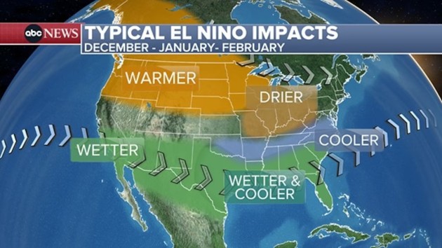
Typical El Nino impacts across the United States
Impacts from El Nino, similar to La Nina, tend to be most consistent and pronounced from late autumn through early spring following the event’s onset, NOAA says. There is usually a delay between the onset of the event and many of the associated effects.
“The more consistent impacts on precipitation and temperature don’t occur until the winter months — so for 2026-27,” Michelle L’Heureux, physical scientist at NOAA’s Climate Prediction Center, said.
Experts caution that the impacts on weather patterns are nuanced. Each season is different, and typical El Nino conditions don’t always materialize.
“Every El Nino is different in terms of timing, magnitude, and geographic extent, and such differences lead to variability in the impacts — on temperatures and rainfall, for example — on a global scale,” Andrew Kruczkiewicz, senior staff researcher at Columbia Climate School, said.
Northeast: Warmer-than-average temperatures are favored across the northern half of the U.S. during meteorological winter (December to February), however its influence is less pronounced in the Northeast, compared to the Upper Midwest and Northwest.
El Nino typically increases the odds of above-average snowfall in the mid-Atlantic and coastal areas of the Northeast as storms often move up the coast. Farther inland, drier-than-average conditions and less snow are more likely.
South: During the winter months, near- to below-average temperatures are favored along the southern tier of the U.S., especially from Texas to the Southeast.
For precipitation, wetter-than-average conditions are typically observed across Texas, the Gulf Coast and Southeast. Below-average precipitation is frequently observed across parts of the south-central Mississippi Valley.
Midwest: Warmer-than-average temperatures are favored from the northern Plains into the Great Lakes in the winter. Drier-than-average conditions are frequently observed across parts of the Ohio Valley and Great Lakes regions.
El Nino typically increases the odds of above-average snowfall in the south-central Plains with below-average snowfall favored in northern Plains and Great Lakes regions.
West: During the winter months, warmer-than-average temperatures are likely across much of the Northwest. For precipitation, wetter-than-average conditions are typically observed across southern California and much of the Southwest, with below-average precipitation frequently observed across parts of the northern Rockies.
El Nino typically increases the odds of above-average snowfall in the southern Rockies, with below-average snowfall favored in the northern Rockies.
Meanwhile, above-average tropical activity in the eastern Pacific increases the likelihood of indirect impacts to the southwestern U.S., such as sending more rain to the region and more frequent flash flood concerns.
Alaska: El Nino impacts in Alaska tend to be more pronounced than across much of the contiguous U.S., with the strongest effects typically occurring during the winter and spring months. During winter, warmer- and drier-than-average conditions are more likely, with less snowfall and reduced snowpack.
Above average temperatures often persist into spring, while precipitation trends closer to average. However, warmer conditions typically mean more precipitation falls as rain rather than snow, prolonging snow deficits.
Hawaii: Rainfall is typically above average across Hawaii the year an El Nino event develops before conditions become drier during the winter months and remain dry well into the following year. The shift toward drier weather can increase the likelihood of drought and elevate the risk of wildfires.
Meanwhile, above-average tropical activity in the eastern Pacific increases the risk of impacts from tropical systems across the Hawaiian Islands.
El Nino’s influence on hurricane season activity
While El Nino is only one of several key factors that influence tropical activity, forecasts now indicate it will be a strong event during the peak of the hurricane season, making it the primary driver of activity in both the Atlantic and eastern Pacific in the coming months.
El Nino conditions often suppress tropical activity during the Atlantic hurricane season by producing unfavorable atmospheric winds. In the Eastern Pacific, the opposite occurs, with favorable conditions supporting above-average hurricane season activity.
As a result, NOAA’s May 21 hurricane outlook is predicting below average tropical activity for the 2026 Atlantic hurricane season with above average activity likely in the eastern Pacific.
“El Nino increases convection (thunderstorms) across the eastern and central Pacific, which causes downstream wind shear over the Atlantic from strong upper-level winds,” Andy Hazelton, an associate scientist at the University of Miami’s Cooperative Institute for Marine and Atmospheric Studies, said.
Vertical wind shear, which refers to changes in wind speed and direction with height in the atmosphere, is often a primary factor in below-average hurricane season activity. Strong vertical wind shear can tear a developing tropical system apart or even prevent it from forming, NOAA says.
“The rising motion over the Pacific also leads to increased subsidence (sinking air) over the Atlantic, which suppresses thunderstorms and tropical cyclone development,” Hazelton added.
Other factors, such as sea surface temperatures, also play an important role in tropical cyclone development and strength. Unseasonably warm ocean waters can partially offset the effects of unfavorable atmospheric winds, according to forecasters.
Copyright © 2026, ABC Audio. All rights reserved.